One method that is being used to make the public aware of the sources of their water is the use of signs that mark the watershed boundaries and label the rivers and reservoirs within the watershed. All too often we pass over rivers and by lakes without realizing the inter-connection between these bodies of water. The watershed boundary signs may help the passerby to realize the extent to which the water whose name they recognize may be separated by miles from the watershed boundaries.
Below are some examples of these signs. Please visit the original sites for more information. If you know of others, we would be happy to post them at this site.
The Chesapeake Bay Commission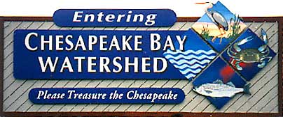 “The signs are part of an ongoing educational effort to help the public understand more about the Chesapeake Bay restoration efforts. They highlight the concept of a watershed and demonstrate that even those who may not be located in close proximity to the Bay can be part of the restoration effort. The Chesapeake Bay is the largest estuary in the United States and receives about half of its water volume from its 64,000 square mile watershed (the other half flows in from the Atlantic ocean at the Bay’s mouth in Virginia).””The Chesapeake Bay Watershed signs were placed by the Chesapeake Bay Commission with the assistance of the states of Maryland, Virginia and Pennsylvania.” “The signs are part of an ongoing educational effort to help the public understand more about the Chesapeake Bay restoration efforts. They highlight the concept of a watershed and demonstrate that even those who may not be located in close proximity to the Bay can be part of the restoration effort. The Chesapeake Bay is the largest estuary in the United States and receives about half of its water volume from its 64,000 square mile watershed (the other half flows in from the Atlantic ocean at the Bay’s mouth in Virginia).””The Chesapeake Bay Watershed signs were placed by the Chesapeake Bay Commission with the assistance of the states of Maryland, Virginia and Pennsylvania.” |
City of Austin, Texas Watershed Protection Department  “In order to increase awareness of Austin’s many watersheds, street signs are installed at watershed boundaries. These signs enable Austinites to get to “know their watershed”. The signs, along with the companion post cards sent to residents, let citizens know that all land is in a watershed and that their property drains directly to a creek or water body. By creating awareness, we hope that citizens avoid polluting.” “In order to increase awareness of Austin’s many watersheds, street signs are installed at watershed boundaries. These signs enable Austinites to get to “know their watershed”. The signs, along with the companion post cards sent to residents, let citizens know that all land is in a watershed and that their property drains directly to a creek or water body. By creating awareness, we hope that citizens avoid polluting.” |
Rivers Alive 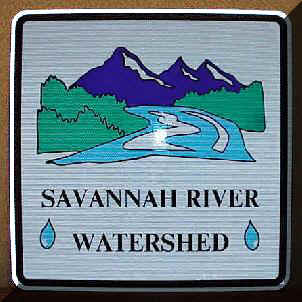 “These watershed signs are produced in part by EPA and distributed through Rivers Alive to qualifying river cleanup organizers. The first 100 cleanup organizers to submit a final tally form will automatically qualify for a 3 x 3 foot sign. All signs are paid for by Rivers Alive.” “These watershed signs are produced in part by EPA and distributed through Rivers Alive to qualifying river cleanup organizers. The first 100 cleanup organizers to submit a final tally form will automatically qualify for a 3 x 3 foot sign. All signs are paid for by Rivers Alive.” |
New York City Department of Environmental Protection 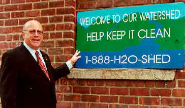 “Commissioner Miele said, ‘The new signs were designed through the cooperation of citizens, civic organizations, municipalities and counties in the watershed, as well as the Catskill Watershed Corporation, the Watershed Protection and Partnership Council, and the New York State Department of Transportation (NYSDOT). In keeping with concerns of watershed residents, the new signs are smaller in scale than the NYSDOT standard and bear a simple message. I want to thank everyone who contributed to creation of the signs, particularly with a special thanks to the State Department of Transportation for installing them.” “Commissioner Miele said, ‘The new signs were designed through the cooperation of citizens, civic organizations, municipalities and counties in the watershed, as well as the Catskill Watershed Corporation, the Watershed Protection and Partnership Council, and the New York State Department of Transportation (NYSDOT). In keeping with concerns of watershed residents, the new signs are smaller in scale than the NYSDOT standard and bear a simple message. I want to thank everyone who contributed to creation of the signs, particularly with a special thanks to the State Department of Transportation for installing them.” |
University of North Carolina at Wilmington 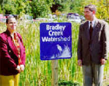 “The University of North Carolina at Wilmington received two Bradley Creek Watershed signs from the City of Wilmington’s Storm Water Services in cooperation with the New Hanover Tidal Creeks Program.””The city is putting up 25 of these blue road signs that feature the name of the watershed and a silhouette of a wading bird. The signs are part of outreach to raise awareness about local watersheds. Storm Water Services gave UNCW the two Bradley Creek Watershed signs in appreciation of the water quality research and support provided by the university’s scientists and administration.” “The University of North Carolina at Wilmington received two Bradley Creek Watershed signs from the City of Wilmington’s Storm Water Services in cooperation with the New Hanover Tidal Creeks Program.””The city is putting up 25 of these blue road signs that feature the name of the watershed and a silhouette of a wading bird. The signs are part of outreach to raise awareness about local watersheds. Storm Water Services gave UNCW the two Bradley Creek Watershed signs in appreciation of the water quality research and support provided by the university’s scientists and administration.” |
New York City Department of Environmental Protection  “Similar signs will be posted on major roads in the eight counties that contain portions of the watersheds of New York City’s upstate reservoirs. The signs will increase awareness of the importance and extensive size of the watershed and will discourage pollution of its streams and reservoirs. The project has been a cooperative effort of the New York City Department of Environmental Protection the New York State Department of Transportation.” “Similar signs will be posted on major roads in the eight counties that contain portions of the watersheds of New York City’s upstate reservoirs. The signs will increase awareness of the importance and extensive size of the watershed and will discourage pollution of its streams and reservoirs. The project has been a cooperative effort of the New York City Department of Environmental Protection the New York State Department of Transportation.” |
Dog River Clearwater Revival 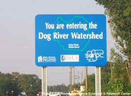 “The Dog River Watershed drains approximately 100 square miles of Mobile County, Alabama, including much of the highly urban city of Mobile, Alabama. Water quality in the watershed is affected by nonpoint source pollution from urban and suburban areas. The major pollutants in the watershed are silt, litter, and bacteria. In 1998, AUMERC began the Dog River Watershed Project to increase public education and concern about the watershed, and to develop a stakeholder-driven management plan.””Fourteen signs have been installed on major roads along the perimeter of the watershed. These signs have increased the awareness of the watershed for thousands of commuters.” “The Dog River Watershed drains approximately 100 square miles of Mobile County, Alabama, including much of the highly urban city of Mobile, Alabama. Water quality in the watershed is affected by nonpoint source pollution from urban and suburban areas. The major pollutants in the watershed are silt, litter, and bacteria. In 1998, AUMERC began the Dog River Watershed Project to increase public education and concern about the watershed, and to develop a stakeholder-driven management plan.””Fourteen signs have been installed on major roads along the perimeter of the watershed. These signs have increased the awareness of the watershed for thousands of commuters.” |
The Watershed Center Grand Traverse Bay 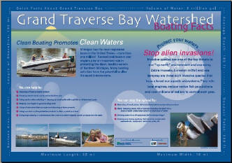 The Watershed Center develops and places educational signs around the Grand Traverse Bay and its watershed. This project was made possible through a grant from the Michigan Department of Environmental Quality’s Nonpoint Source Program. The Watershed Center develops and places educational signs around the Grand Traverse Bay and its watershed. This project was made possible through a grant from the Michigan Department of Environmental Quality’s Nonpoint Source Program. |